Land surveying has come a long way. Traditional tape measures, theodolites, and manual sketches once dominated the industry. Today, the field is being reshaped by modern land surveying techniques, creating a landscape that is more precise, efficient, and dynamic than ever before. With ongoing advances in technology, the outlook is promising and filled with opportunity.
From Conventional Methods to GPS Surveying Technology
The Rise of Satellite-Based Positioning
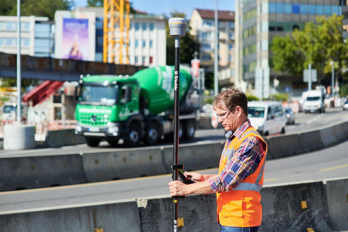
One of the most transformative shifts in land surveying has been the adoption of GNSS (Global Navigation Satellite System) surveying. These systems make use of satellite constellations, such as GPS, Galileo, GLONASS, and BeiDou, to deliver real-time positioning data. This allows surveyors to obtain centimetre-level accuracy on site, particularly when using techniques such as Real Time Kinematic (RTK) corrections.
Efficiency Gains and Control Networks
RTK surveying uses a fixed base station and a mobile receiver (a rover), enabling very precise measurements almost instantly. In other scenarios, surveyors use Post‑Processed Kinematic (PPK) methods, where they collect GNSS data and correct it later to improve accuracy. Static GNSS surveys also provide long-duration control points, helping to build accurate geospatial frameworks for large projects.
These techniques drastically reduce the time spent on site, improve productivity, and shrink the margin for error. As GNSS hardware continues to become more affordable and portable, its use in land surveying keeps growing.
Emerging Developments in Current Land Surveying Methods
Beyond GNSS, surveyors are increasingly turning to a range of advanced surveying methods that push the boundaries of what is possible.
Drones and Aerial Imaging
Unmanned Aerial Vehicles (UAVs), commonly known as drones, have become essential tools in land surveying. Equipped with cameras, multispectral sensors, or LiDAR units, drones fly over terrain and capture vast quantities of data quickly. The benefit is two-fold: they safely access difficult or hazardous terrain, and they produce high-resolution topographic models in far less time than ground teams.
Total Stations and Robotic Surveying
Another staple of modern techniques is the robotic total station. These instruments merge electronic distance measurement with fully automated angle tracking. A single operator can control a robotic total station remotely, speeding up data collection and reducing the risk of human error. Reflectorless models make it possible to measure points without needing a prism, which is particularly useful on complex or hazardous sites.
The Revolution of 3D Laser Scanning Surveying

At the heart of the most exciting change in the profession is 3D laser scanning surveying, also called LiDAR (Light Detection and Ranging) or terrestrial laser scanning (TLS).
Capturing the World in Point Clouds
Laser scanners emit rapid pulses of laser light and measure the time it takes for each pulse to bounce back. The result is a dense “point cloud” of millions of three-dimensional data points that form a highly detailed model of terrain, objects, buildings, or infrastructure. This enables surveyors to produce digital representations with millimetre-level precision.
Scanning Modes and Mobility
There are different modalities of 3D laser scanning. Terrestrial laser scanning (TLS) is suitable for fixed, ground-based surveys such as buildings, tunnels, or rock faces. Mobile LiDAR systems integrate scanners with moving platforms like vehicles. For very large and remote areas, aerial LiDAR mounted on drones or aircraft enables rapid topographic data collection across wide swathes.
Accuracy, Change Detection, and Monitoring
One powerful application of TLS is detecting changes over time. For instance, a study measured complex canyon topography using repeated scans and could detect differences as small as 6 mm. These techniques help monitor erosion, deformation, or structural shifts in natural or built environments.
Bringing Technologies Together to Shape the Next Era of Surveying
Synthesising Technologies
The future of surveying lies not in a single magic tool but in the integration of multiple technologies. GNSS, drones, robotic stations, LiDAR, and GNSS-enabled aerial platforms can work together. For example, GNSS is used for georeferencing point clouds generated by laser scanning, and drones provide aerial coverage while ground teams validate key control points.
Smart Data Processing
Advanced data processing has become indispensable. High-density point clouds, GNSS observations, and aerial images all feed into software systems and cloud platforms. Real-time data upload, combined with rapid correction, means surveyors can check the quality of work on site. Integration with Geographic Information Systems (GIS) helps to visualise, analyse, and interpret spatial data, making survey results more meaningful for planning and construction.
Artificial Intelligence, Machine Learning, and Reality Capture
Artificial intelligence is beginning to influence the way survey data is processed. Machine learning algorithms can detect features in point clouds, classify terrain types, and even predict future changes. Reality capture with 3D laser scanning generates digital twins of the environment. These models feed into building information modelling (BIM), augmented reality, or virtual reality environments, allowing clients and stakeholders to interact with precise simulations of their site.
Challenges and Considerations
No technology is risk-free or free of trade-offs. High-precision GNSS systems require a robust base‑station setup and ideal satellite visibility. Dense vegetation or urban canyons can reduce signal quality. Laser scanners produce enormous volumes of data, meaning on-site scanning may be fast, but post-processing takes time and storage.
Cost is another factor. While purchasing LiDAR and high-end drones represents a large initial investment, many organisations find that reduced labour and faster turnaround justify the expense over time. Skilled staff are needed to operate these advanced tools and to process the data responsibly.
Looking Ahead
In the next decade, advanced surveying methods are likely to get even more powerful. GNSS hardware is expected to become more accurate and reliable, even under difficult conditions. Drones may fly autonomously for multi-session mapping missions, with LiDAR-based SLAM (Simultaneous Localisation and Mapping) enabling repeat surveys over time. Virtual and augmented reality will offer immersive ways to visualise survey results.
These innovations support smarter decision-making across industries: urban planning, infrastructure development, environmental monitoring, and construction management. As precision improves and cost comes down, modern surveying technologies will become standard for large and small-scale projects.
The Role of Surveyors in Tomorrow’s World
Land surveyors in Melbourne will remain essential even as technology changes. Their expertise ensures that data is collected, validated, and interpreted correctly. The shift from old‑school manual methods to modern land surveying techniques means that professionals need to upskill in working with GNSS, processing point clouds, using cloud software, and interacting with BIM platforms.
Surveyors who embrace 3D laser scanning surveying and other advanced tools will be better placed to serve clients who demand accuracy, speed, and rich digital deliverables. Forward-thinking firms that integrate these innovations position themselves as leaders in the future of surveying.
Conclusion
The world of land surveying is changing fast. From GPS surveying technology to 3D laser scanning, new techniques make data richer, projects safer, and work more efficient. The focus is shifting from tools alone to smart integration of platforms, software, and real-time data. As these solutions become more accessible, surveyors can offer stronger value and accuracy. For major projects, working with topographic land surveyors in Melbourne who use modern workflows ensures precise results and smooth progress from planning to construction.
Ready to step into the future? Trust GREATER MELBOURNE SURVEYORS to bring precision, innovation, and reliability to your next project.